CAIRS:
Cahokia Airborne Imaging & Remote Sensing

Cahokia Mounds was the largest and most complex pre-Columbian city north of Mexico, flourishing between A.D. 1050–1350 near present-day St. Louis. At its peak, it was a major Mississippian urban center with a population of 10,000–30,000 people and influence across the Mississippi Valley. The city featured monumental earthen mounds, platforms, conical, and ridge-top structures organized around plazas and neighborhoods, with
Monks Mound as the largest earthen structure in the Americas. Cahokia was a hub of political power, religious ceremony, trade, and intensive agriculture, reflecting a highly organized and sophisticated Indigenous society.


The Cahokia Airborne Imaging & Remote Sensing (CAIRS) project is an integrated remote-sensing initiative designed to document, analyze, and protect the ancient urban landscape of Cahokia Mounds, North America’s largest pre-Columbian city. Using advanced airborne LiDAR, multispectral and hyperspectral imaging, UAV photogrammetry, and GIS-based spatial analysis, CAIRS aims to create a comprehensive high-resolution digital model of the Greater Cahokia landscape.

CAIRS also supports cultural heritage management by generating precise datasets for monitoring site condition, guiding preservation strategies, and enabling virtual access for researchers, educators, and descendant communities. Through collaboration with academic partners, local agencies, and Indigenous stakeholders, the project advances both scientific understanding and responsible stewardship of one of North America’s most significant archaeological landscapes.

Much of Cahokia’s history remains unknown because its builders left no written records, and large portions of the ancient landscape have been altered or destroyed. What we know comes from excavations, remote sensing, and surviving material remains. Still, major questions persist, like how leadership was organized, how neighborhoods interacted, what daily life looked like, and why the city declined after A.D. 1350. Limited excavation, mound destruction, and a fragmented archaeological record mean that Cahokia remains one of the most complex yet least fully understood ancient cities in North America.

Through advanced geospatial analysis and mapping, Terra Incognita aims to address major unanswered questions about Cahokia’s past. By integrating multiple datasets, we can clarify the city’s urban planning, the relationship between ceremonial and residential zones, patterns of movement, the roles of minor mounds, visibility networks, environmental modification, and factors behind Cahokia’s rise and decline.
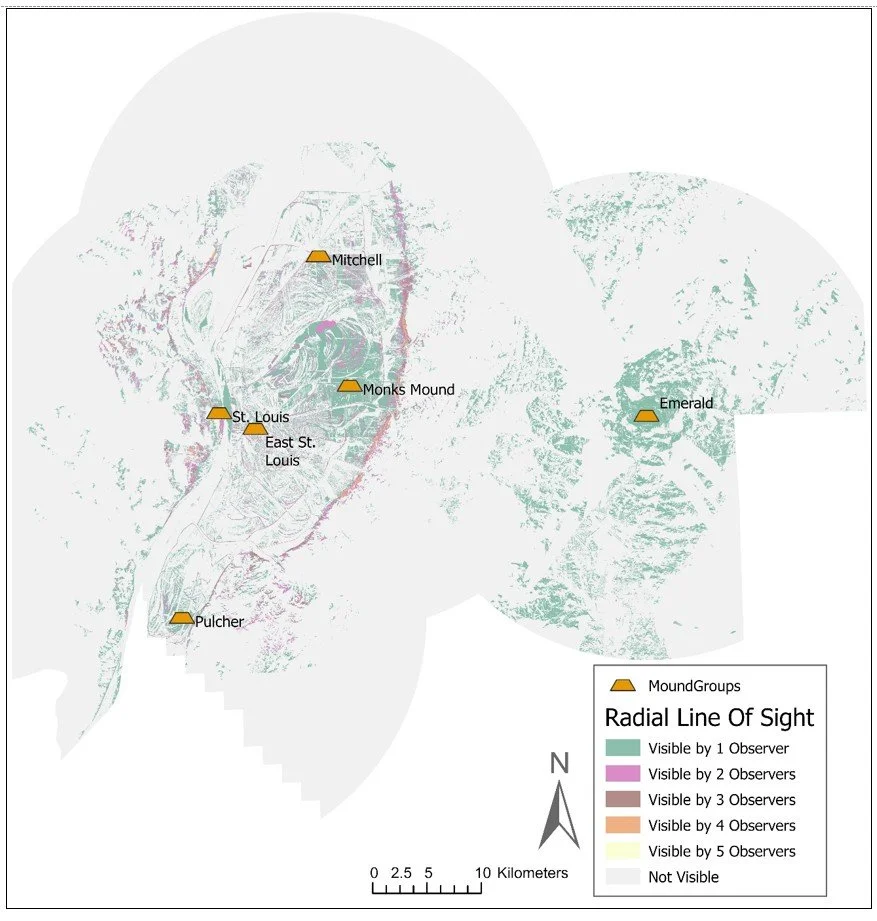
In Pierce, Daniel E., and Timothy C. Matisziw 894 2018 Prehistoric Panopticon: Settlement Visibility at Ancient Cahokia Mounds. Space and 895 Culture 24 (2): 216-239, showed that Cahokia’s leaders intentionally designed the landscape to control what people could see. High-resolution viewshed modeling revealed that major mounds were placed to maintain long-distance visual connections across the region, while visibility inside the palisade was deliberately restricted. These patterns demonstrate that sightlines were a key part of how Cahokia organized ritual, movement, and social power.

We expanded the previous work in Vilbig, Justin M., and Christopher Bodine. “Constructing Greater Cahokia: Site Concentrations and Visibility Surrounding America’s First City.” Manuscript under review, Journal of Computer Applications in Archaeology- in review. and showed that Cahokia’s settlement pattern was highly organized, with mound groups and neighborhoods placed in deliberate clusters across the landscape. Using regional visibility modeling and spatial statistics, the article demonstrated that most mounds and many residences were positioned within shared sightlines, creating a network of visually connected communities. These patterns reveal that Cahokia’s leaders used landscape design, especially visibility and spatial clustering, to structure social integration, movement, and influence across the region.
In Vilbig, J. M., Bodine, C. (2020). Archaeological surveying with airborne LiDAR and UAV photogrammetry: A comparative analysis at Cahokia Mounds. Journal of Archaeological Science: Reports, 33, we showed that high-resolution UAV imagery can reliably capture the subtle topography of Cahokia’s mounds, plazas, and earthworks—often matching or even surpassing LiDAR in open areas. It revealed fine details of mound edges, construction episodes, erosion patterns, and modern disturbances that are invisible on the ground. This demonstrated that drone-based photogrammetry is a powerful, low-cost tool for documenting and reconstructing Cahokia’s rapidly disappearing landscape.
In Bodine, Christopher., NASA Airborne Synthetic Aperture Radar (AIRSAR): SAR data for Detection and Preservation: NASA and Archaeology from Space: A Symposium in Honor of Dr. Thomas L. Sever. NASA (Forthcoming). We showed that SAR data collected by NASA’s 1999 radar flight over Cahokia revealed deep and detailed information about the ancient landscape that optical imagery cannot show. Using P-, L-, and C-band data, the analysis identified soil-moisture contrasts, buried geomorphic features, possible mound bases, and subtle landscape modifications hidden beneath plow zones. This work demonstrated that radar, especially multifrequency AIRSA, can detect archaeological and environmental features at Cahokia that have remained invisible for decades.


The work of CAIRS and Terra Incognita is ongoing, with several analyses already underway and multiple papers in preparation. New projects, ranging from satellite-based landscape modeling to expanded UAV and LiDAR surveys, are currently progressing through the publication pipeline. As new datasets are processed and integrated, CAIRS continues to refine our understanding of Cahokia’s landscape and reveal discoveries that will shape future research.